Derby sits on the edge of the Pennines, where the River Derwent cuts through Carboniferous Millstone Grit and softer shales. Elevations here rise sharply from 40 m to over 200 m within a few kilometres, creating natural corridors for debris flows during intense rainfall. A proper debris flow analysis in Derby is essential for any development on these steep valley sides. The local geology means colluvium and head deposits mantle the slopes, and these materials can mobilise rapidly when saturated. We combine field mapping, geomorphological interpretation, and numerical modelling to quantify runout distances and impact forces. Before modelling begins, we often recommend a granulometria to characterise the grain-size distribution of the source material, as fine content strongly influences flow behaviour.
In Derby, the transition from Millstone Grit to shale creates a natural slip surface that can mobilise into a debris flow within minutes.
Process overview
Local context
In Derby, many older properties sit on the toes of colluvial fans that are now being redeveloped. We frequently see that original site investigations missed the debris flow hazard entirely, because the fan surfaces appear stable under dry conditions. The real risk emerges during a 1-in-100-year storm, when the upper catchment delivers a sudden pulse of water and sediment. A debris flow analysis in Derby must account for this lag between trigger and impact. Ignoring it can lead to blocked drainage, structural damage, or even loss of life. We always map the full catchment, not just the development footprint, and we check for legacy mining features that can alter drainage paths.
Reference standards
Eurocode 7 (EN 1997-1:2004) – geotechnical design, BS 5930:2015 – site investigation code of practice, FHWA-NHI-05-039 – rockfall and debris flow design guidelines
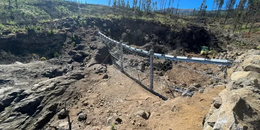
Additional services
Geomorphological Mapping and Hazard Zonation
We produce detailed maps of source areas, transport zones, and depositional fans using LiDAR, aerial imagery, and field surveys. The output is a hazard zonation that identifies no-build zones, mitigation requirements, and safe setback distances.
Numerical Modelling of Flow Dynamics
Using FLO-2D and DAN3D, we simulate debris flow initiation, propagation, and deposition. The models are calibrated against historical events in the Derbyshire region and yield runout distances, flow depths, and impact pressures at the property scale.
Mitigation Design and Monitoring
Based on the analysis, we design check dams, debris basins, or deflection berms. We also specify monitoring systems such as wire-line sensors and rain gauges to provide early warning for existing developments at risk.
Typical parameters
Common questions
What is the difference between a debris flow and a landslide?
A landslide involves coherent movement of a soil or rock mass along a defined failure surface. A debris flow is a fast-moving mixture of water, soil, and rock that behaves like a viscous fluid. In Derby, many shallow translational landslides on the shale slopes transition into debris flows when water content exceeds about 30%.
How is debris flow analysis carried out in Derby?
We follow a three-stage process: desk study of BGS records and LiDAR, field mapping of source zones and fan morphology, and numerical modelling with FLO-2D or DAN3D. The models are calibrated using local rainfall data from the Environment Agency and historical flow paths observed in the Derwent valley.
How much does a debris flow analysis cost in Derby?
The cost typically ranges from £1,130 to £3,700 depending on catchment size, modelling complexity, and whether laboratory testing is needed. A standard residential plot with a small catchment falls at the lower end, while a large hillside development with multiple source zones is at the upper end.
Do I need a debris flow analysis for a single house extension in Derby?
It depends on the location. If the property sits on or below a colluvial fan mapped by BGS, or within 50 m of a stream channel that drains steep terrain, then we recommend at least a qualitative hazard screening. Many local planning authorities in Derbyshire now request this as part of a flood risk and geohazard assessment.